Chapter 1 of 121566–1842
Low tenements and an old soap works
Sekforde Street is named after Thomas Seckford, an Elizabethan lawyer who left part of his Clerkenwell estate to endow almshouses at Woodbridge in Suffolk. According to the Survey of London, he bought the land in 1566. It was then the larger part of St Mary’s Close, a field that had belonged to the nunnery of St Mary. His charity remained the ground landlord until the 1970s.
By the 1820s the estate was, in the Survey’s words, “a fairly haphazard accumulation of alleys and courts, largely industrial in character but with many small houses and tenements”. A plan printed for Parliament in 1831 shows it as it stood before Michaelmas 1827: “Low Tenements”, a “Floor Cloth Factory”, an “Old Soap Work” and ruinous buildings, with the new streets drawn in dashed lines across them.
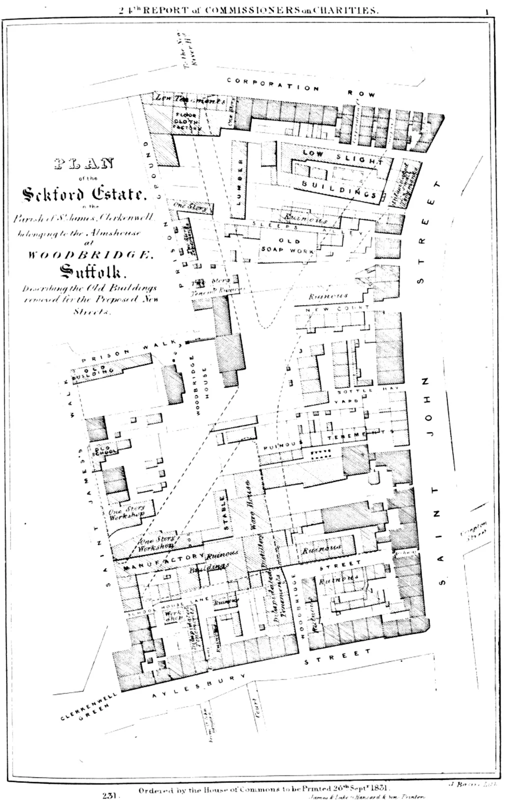
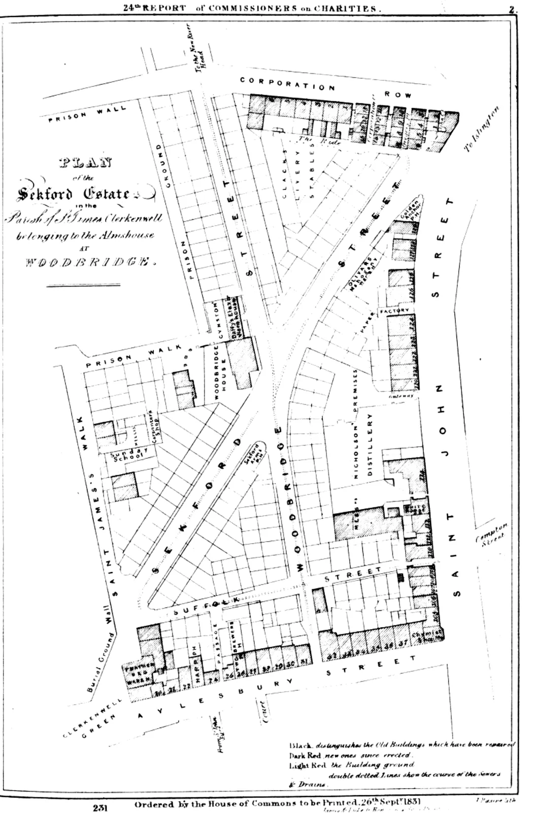
The estate surveyor was C. R. Cockerell. Most of the work fell to his assistant, James Noble, who in practice had to agree the plans and elevations of every new building. Their layout, ready by August 1827, made Sekforde Street the main road, crossed at its centre by the narrower Woodbridge Street. The bank’s neighbours went up alongside it. Among the estate’s few buildings that were not houses, the Survey singles out one: “Alfred Bartholomew’s Finsbury Savings Bank is in a showy Italianate style, thought appropriate for banks: Noble was very pleased with the result.”
Notes
- Survey of London, vol. 46: South and East Clerkenwell, ed. Philip Temple (English Heritage / Yale University Press, 2008), p. 73, paras [p1] and [p3], https://www.british-history.ac.uk/survey-london/vol46/pp72-85; W. J. Pinks, The History of Clerkenwell, 2nd edn (1881), p. 176; Dictionary of National Biography, “Seckford, Thomas” (1897): “sworn one of the masters of request in ordinary on 9 Dec. 1558, and he also held the offices of surveyor of the court of wards and liveries”. Seckford’s dates differ between sources: the Survey gives c.1517–87, the DNB 1515?–1588.
- Survey of London vol. 46, p. 74, para [p9]. The name St Mary’s Close is independently attested by [Thomas] Cromwell, History and Description of the Parish of Clerkenwell (1828), p. 240, and Pinks (1881), p. 176; the purchase date of 1566 and the link with the nunnery rest on the Survey.
- Survey of London vol. 46, p. 73, para [p1] (“The Seckford Charity, now the Seckford Foundation, continued as landlord until the 1970s”) and p. 74, para [p8]. Most of the estate then passed to the London Borough of Islington; the sources give the date of the transfer differently.
- Survey of London vol. 46, p. 73, para [p2].
- 24th Report of the Commissioners for inquiring concerning Charities (1830), Parliamentary Papers 1831 (231) XI.1, p. 490 (the governors’ solicitor supplied “two plans, one of them showing its state previous to Michaelmas 1827”), and folding plans no. 1 and no. 2, “Ordered by the House of Commons to be Printed 26th Septr 1831” (Google Books 9joSAAAAYAAJ, PT2 and PT4). Plan no. 2 shows “SEKFORD STREET” and “WOODBRIDGE STREET” laid out. A private Act of 1826 (7 Geo. IV c. 24) let the governors grant leases of up to 99 years; according to the Survey (p. 74, para [p12]) the rebuilding used 75-year leases almost throughout.
- Survey of London vol. 46, p. 74, paras [p13]–[p14] (“By the late 1830s Noble had taken over more or less completely”), and p. 76, para [p26]. Cockerell’s surveyorship is independently confirmed by the 1830 report, p. 490 (“Mr. Cockerell, the surveyor to the estate”). Cockerell was also surveyor to the neighbouring Northampton estate.
- Survey of London vol. 46, p. 74, para [p16]. The two new streets are also described by Cromwell (1828), Appendix p. 448, and shown on the 1831 plan no. 2.
- Survey of London vol. 46, p. 76, para [p25] (nearly all the new houses were of the third rate; in the Survey’s view their one distinguishing feature is “the treatment of the parapets as a rudimentary diglyph frieze”), and p. 82, summary table (“Nos 17, 18. 1839–40. Benjamin Slipper & Joseph Cornick, builders”; “No. 19. 1839–40. Charles Shore, builder”; fn. 47). Historic England dates the neighbours differently: list entries 1195752 and 1195753 (“Terraced houses. c.1835.”).
- Survey of London vol. 46, p. 77, para [p29]. There is no footnote; Noble’s reaction rests on the Survey’s reading of the estate papers. The Survey calls Sekforde Street, the estate’s most important street, “the best preserved, retaining the majority of its original houses” (p. 80, para [p57]).